Category:Kerkstraat 38, Voorburg
Jump to navigation
Jump to search
| Object location | | View all coordinates using: OpenStreetMap |
|---|
building in Leidschendam-Voorburg, Netherlands  | |||||
| Upload media | |||||
| Instance of | |||||
|---|---|---|---|---|---|
| Location | Voorburg, Leidschendam-Voorburg, South Holland, Netherlands | ||||
| Street address |
| ||||
| Located on street | |||||
| Heritage designation |
| ||||
 | |||||
|
This is a category about rijksmonument number 37956
|
| Address |
|
Media in category "Kerkstraat 38, Voorburg"
The following 3 files are in this category, out of 3 total.
-
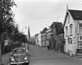 Overzicht - Voorburg - 20245528 - RCE.jpg 1,200 × 952; 225 KB
-
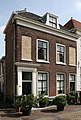 Voorburg - Kerkstraat 38 RM 37956.jpg 2,600 × 3,850; 9.88 MB
-
 Voorgevels - Voorburg - 20245536 - RCE.jpg 807 × 1,200; 203 KB

